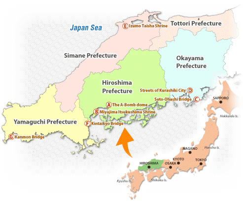
Location of the Chugoku Region
Japan is an island nation that lies off the eastern coast of the Asian continent and comprises four major islands-Hokkaido, Honshu, Shikoku, and Kyushu-covering an area of approximately 380,000 km a population of roughly 120 million.
The Chugoku region is located at the southwestern part of Honshu Island and occupies 32,000 km of the total land area of Japan), with a population of 7.7 million (6.1% of the total).
Access to the Chugoku Region
The Chugoku region can be easily accessed from most major cities of the world. There are regular direct flights from Seoul and Hong Kong to Hiroshima and Okayama International Airports, as well as shinkansen super express train and domestic air services from Tokyo (Haneda International), Osaka and Fukuoka International Airports to various cities in the region.
Economy of the Chugoku Region
Major industries in the Chugoku region are steel, petrochemical and shipbuilding, which were established during Japan's economic high-growth era of the 1960's. Centered in industrial complexes on the coast of the Inland Sea are located today's major growing industries such as automobile manufacturing and education-related businesses.
I In 2000, Japan's GOP totaled 498 trillion yen, about 6% of which was accounted for by the Chugoku Region.
History of the Chugoku Region
Historically, the Chugoku region was characterized by its as a "contact point" between the Asian mainland and Nara and Kyoto, the ancient seats of the Japanese central government. The region was once governed by the Choshu clan, which produced many distinguished patriots who contributed to the Meiji Restoration. The region is also known for Omori Ginzan, where silver production once accounted for a major portion of the world output. The destruction of Hiroshima City by the first atomic bomb on August 6,1945 is well-known. Today, Hiroshima is a thriving city, active in the preservation of world peace. It has been designated as "Peace City".
Climate/Natural Disasters
The Chugoku Region can be divided into two areas: Sanyo (western Honshu, facing the Inland Sea) and Sanin (western Honshu, facing the Japan Sea). When comparing the climates of both areas, the annual average temperature in Sanin is one or two degrees lower than in Sanyo. Average Temperature in January (Matsue 3.7 Hiroshima 5.9 Average Temperature in August Matsue 26.5 Hiroshima 28.4 (1999) The Sanin Region has high rainfall in winter, Sanyo in summer.
I In late June 1999, a torrential rainstorm struck the Chugoku Region. In Hiroshima Prefecture, 31 people were killed or reported as missing, and damages in monetary terms from the disaster totaled 67 billion yen. In addition, disasters caused by severe winds, storms and floods have occurred 7 times over the past 30 years and damages have exceeded 50 billion yen.
|
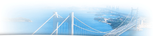
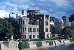 A. The A-Bomb dome A. The A-Bomb dome(Hiroshima) The Dome comme- morates the dropping of the first atomic bomb in history used against a civilian population on August 6, 1g45. The Dome was registered on UNESCO' a World Cultural Heritage list as a symbol of Hiroshima's pledge to seek lasting world peace.  B. Miyajima Itsukushima Shrine B. Miyajima Itsukushima Shrine(Hiroshima) Miyajima of Aki, one of the three most scenic spots in Japen, is famous for its vermilion-painted "torii" gate, and Itsukushime Shrine in the l2th-century architectural style, reflected in the see. 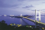 C. Seto-Ohashi Bridge C. Seto-Ohashi Bridge(Okayama) This bridge was opened to traffic in 1988 to link Shikoku and Honshu, Japan a largest land mass. With a total length of 9,368m, it consists of six bridge sections and four deducts. The whole roots is a double construction, with an expressway running above a railway. 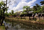 D. Streets of Kurashiki City D. Streets of Kurashiki City(Okayama) The streets a the Kurashikigawa River, where beats of various sizes plied during the Edo period (1600-1868), have been designated as Important Cultural Properties by the national government. 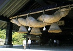 E. Izumo Taisha Shrine E. Izumo Taisha Shrine(Shimane) This shrine boasts a giant straw rope, 13m long and weighing 15 tons, that looks as if it represents Izumo (Shimane Prefecture), depicted in the Kunibiki myth. 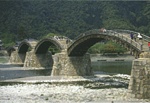 F. Kintaikyo Bridge F. Kintaikyo Bridge(Yamaguchi) This bridge, regarded as one of the three most famous bridges in Japan, was originally built in 1673. This unique and highly sophisticated five-arched wooden bridge is said to have no negative factors in terms of modern bridge engineering. 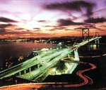 G. Kanmon Bridge G. Kanmon Bridge(Yamaguchi) With a total length of 1068m, Kanmon Bridge (completed in 1973) is a suspension bridge connecting Kyushau with the mainland of Japan. |